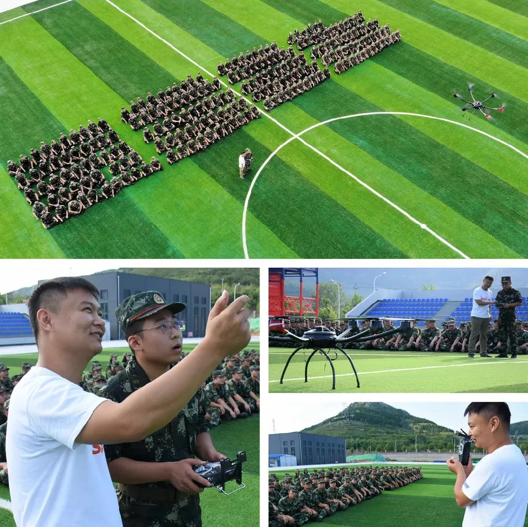
Firefighting UAV Working Together with Payloads Fire Extinguishing Bombs
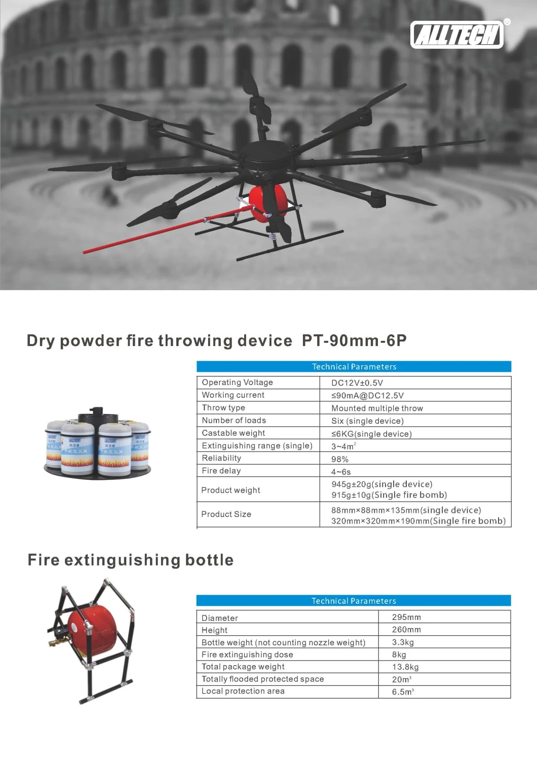
Product Features
Features:
Handheld Ground Station K2
K2 is a handheld ground station integrated with industrial three-proof computer and digital radio remote control system. It supports dual-system platform software development with functions of drone and gimbal payload remote control, real-time flight status and remote state feedback, and route planning. Industrial-grade computer and military-grade transmission links not only ensure the safety and stability of aircraft control, but also guarantee the easy operation and portable transportation.
Features:
GCS Ground Station Software(English version optional)
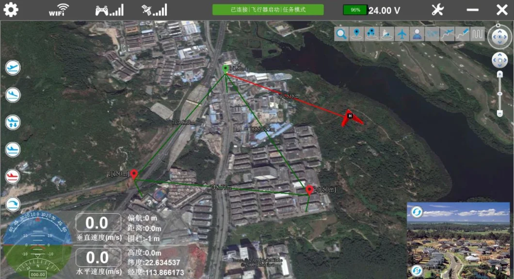
The SPELL-IG/A integrated ground station system can edit map waypoints, plan flight routes and achieve real-time flight attitude feedback. Designed for over-the-horizon flight, the product is used in emergency rescue, detection, aerial photography and other fields. The SPELL-IG/A integrated ground station system not only ensures the stable flight state and safety of the drone, but also makes the interface easy to operate. The drone can fly according to the flight route set in the ground station software in advance. The set route could be modified in the ground station software during the flight to achieve autonomous flight.
The system adopts a portable suitcase design, which integrates digital radio and video transmission modules and can be quickly deployed and installed in a short time. The ground station features a high-brightness display that delivers crisp images even in bright light environments. The device has a built-in high-definition video receiver, which can display the aerial picture in real time on the display screen and with a voice prompt function, which makes the operator more targeted when performing tasks.
Features
Technical Specifications
Brief introduction drone marine surveillance use
Through wireless data transmission link, the drone with different mission payloads can transmit the site information not only to the information processing and analysis system on the ground station that can forward the target information to the command center simultaneously, but also to the nearby cruise ships for quick response to the tasks. By dynamic surveillance and real time tracing on the maritime emergencies, ocean disaster and change of maritime environment, it offers real time field data for marine forecasters to make rapid alert, providing a scientific decision basis and solution for the maritime management department.
Regular patrol ships have disadvantages of low speed, narrow view, long patrol intervals and big limitation to natural conditions. Manned patrol aircrafts are influenced by the restriction of air traffic control with high use cost. However, the drone for maritime patrol features for low purchasing cost, low ground support requirements, strong maneuverability and no personnel security risks. More importantly, it offers a broad view, fast reaction and high work efficiency. The sea, the land and the air trinity comprehensive coverage can be realized when cooperated with Vessel Traffic System( VTS), patrol boats and law enforcement vessels, pushing the maritime static supervision gradually to the three dimensional supervision mode with dynamic static integration.
Marine environment surveillance
Spilled oil monitoring: cooperate with the sea patrol boats to make surveillance on the oil field work boats by using the drone to gather evidence of the spilled oil and chemical accidents. According to the task equipments like sensor and so on, the drone enables to monitor the sea pollution drift and diffusion situation, locate the sudden oil spill, and to estimate the oil spill area and drift path.
Emergency action: after oil spill and chemical accident, the drone can arrive at the accident scene at regular time and real time transmit the field scene to the command center.
Emission monitoring: through irregular night inspection to restrain night concealed emission.
Animal protection: irregular patrol on the protection sea for timely detection of stealing and poaching behavior.
Red tide monitoring and analysis: locate red tide area and ration red tide area.
Aftersales service
Offer local pilot training. Training course includes drone theory knowledge,field demo,practical flight training,drone maintenance and so on.
Product Features
- Carbon fiber integrated molding with high rigidity and light weight; supports more than 65 minutes flight time.
- Innovative upturned arm design for flying stability and strength, ensuring wind tolerance up to 14 m/s.
- Able to fly at elevation of 5000m (16500 ft).
- Full HD 1080i/P real time video transmission.
- Detachable structure, get ready to fly within 5 minutes.
- Highly integrated rainproof gimbal unit with good rain performance.
- Intelligent flying control system, supports manual precision control and autonomous flight.
Technical Parameters Diagonal wheelbase 1600 mm Standard take-off weight 9.8 kg Max take-off weight 14.4 kg Max payload weight ≥5 kg Flight time ≥65 min (@9.8kg) Wind loading rating 14 m/s Max flight speed 15 m/s Relative flight speed 1000 m Max working altitude 5000 m GPS position accuracy vertical: ±1.5 m
horizontal: ±2 mRemote control distance 7 km(up to the environment) GS control distance 10 km Center Frame Packing Case Dimensions 1150 x 440 x 500 mm Frame Arm Packing Case Dimensions 1120 x 540 x 380 mm
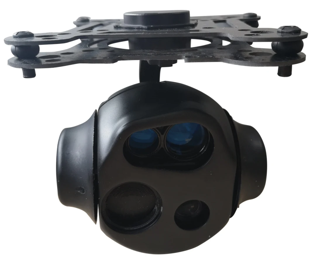
Features:
- 30* optical zoom;
- 1080P HD output;
- Real-time switching of visible and thermal imaging video;
- Direct control of drone signals, integrated transmitter for video compression encoding and real time HD output;
- Pointing zoom function;
- Temperature detection and alarm function, ranging function, target positioning and tracking function;
- The control speed is automatically adjusted according to the focal length to ensure the user experience.
| Technical Specification | ||
| Power supply | Working voltage | DC11V~DC13V |
| Maximum current | 2.1A@DC12V | |
| Gimbal | Gimbal title angle | -90°~+30° |
| Gimbal yaw direction | ±165° | |
| Angle control accuracy | ±0.02° | |
| Maximum angular velocity control speed | Pitch: 12°/s, yaw: 12°/s | |
| Target positioning | Self-contained laser ranging module, the farthest distance measurement is 1.5KM, and the positioning accuracy radius is 25M. | |
| Tracking function | With target tracking function, it can track selected people or objects. | |
| Transmitter | Working frequency range | 328~352MHz/560~760MHz/ (See the body label for details) |
| RF bandwidth | 2/3/4/6/7/8MHz | |
| Output power | 12~30dBm adjustable, step 1dB | |
| Power flatness | Full band ≤2dB, ≤1dB within 8MHz | |
| C/N | ≥28dB @ 27dBm | |
| SHG | >52dBc | |
| RS232 data interface | Standard RS232 level, support 1200~115200 bps | |
| Encryption | AES128/AES256 | |
| HDMI | Version | HDMI 1.4a |
| resolution | 1080P30 | |
| Encoding | Audio and video bitrates | 64,96,112,128,160,192,224,256,320,384Kbps adjustable |
| Audio coding | Mpeg1 Layer 2 | |
| Format | YCbCr4:2:0 | |
| Video coding | H.264 | |
| Video bitrate | 500kbps~16.68Mbps adaptive | |
| Encoding delay (end-to-end) | Minimum 300ms (with low-latency receiver) | |
| HD camera | Sensor | (30*zoom) 1/5.8 inch, CMOS |
| Total pixel | 2.16 megapixels | |
| Resolution | 1920(H)X 1080(V) | |
| optical zoom | 30*zoom | |
| Aperture | FNO:1.5-4.0 | |
| Video compression | H.265/H.264/H.264H | |
| HDMI output | Default 1080 P30 | |
| Thermal Imaging | Detector type | Amorphous silicon infrared micrometer |
| Pixel spacing | 17 μm | |
| Resolution | 640(H)×480(V) | |
| Response band | 8~14μm | |
| Lens focal length | 25mm | |
| Electronic zoom | Maximum 8* | |
| Laser Ranging | Wavelength | 905nm (human eye safety) |
| Irradiation distance | 3-1600M | |
| Beam divergence angle | 3.2mrad | |
| Laser ranging distance | 1.5m | |
| Environment | Working temperature | -40°C~60°C |
| Storage temperature | -45°C~65°C | |
| Humidity | Working normally in a hot humid environment of 70% ± 2% @ 40 ° C | |
| Physical size | (30 *zoom) L* W* H: about 146 * 146 * 177mm; | |
| Weight | 1.0kg ± 0.05kg | |
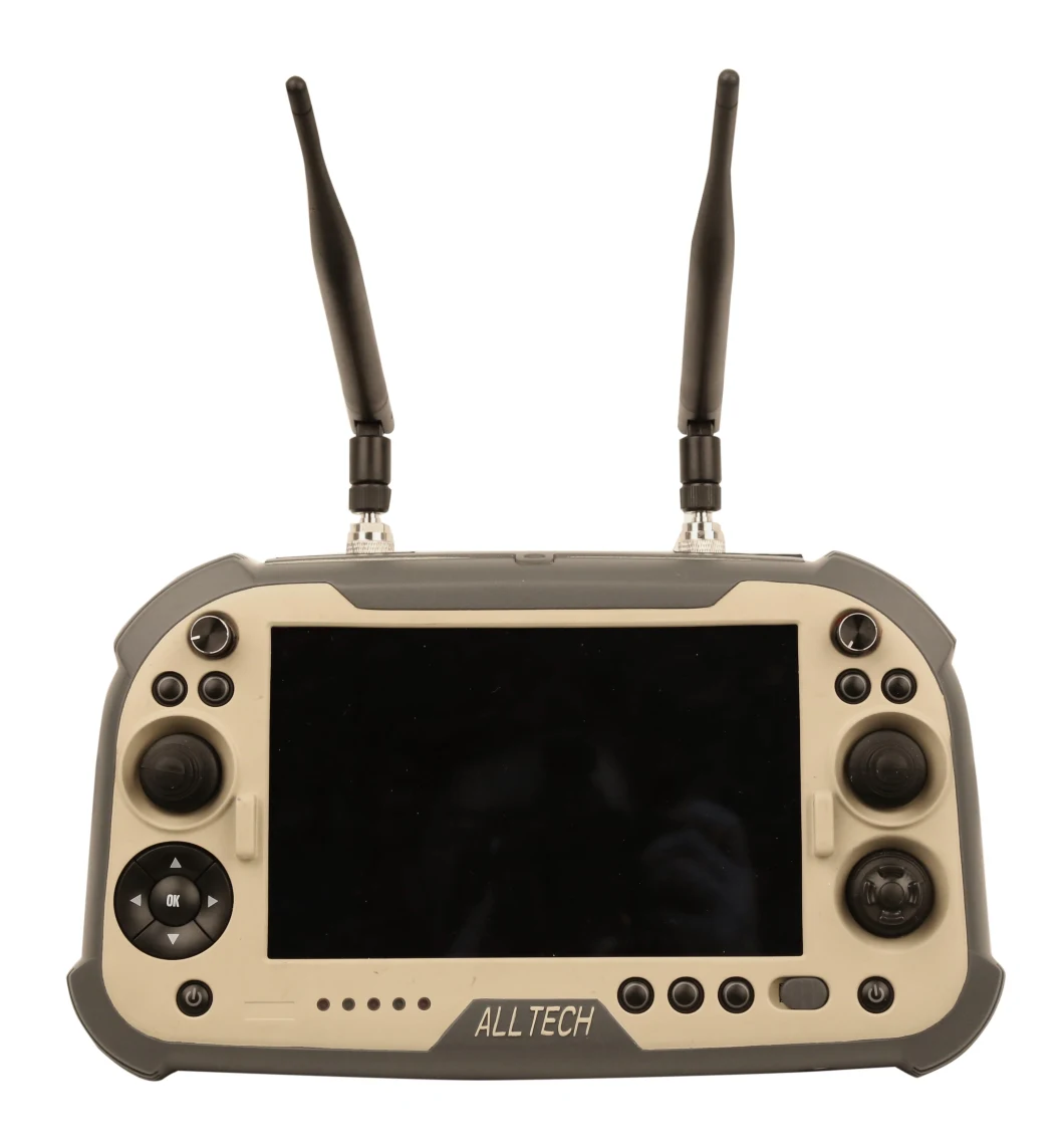
Handheld Ground Station K2
K2 is a handheld ground station integrated with industrial three-proof computer and digital radio remote control system. It supports dual-system platform software development with functions of drone and gimbal payload remote control, real-time flight status and remote state feedback, and route planning. Industrial-grade computer and military-grade transmission links not only ensure the safety and stability of aircraft control, but also guarantee the easy operation and portable transportation.
Features:
- Google Earth full-screen display, precise setting of waypoint tasks and support for real-time modification of waypoints, flight path/critical event SD card storage and information playback;
- Support one-button take-off, one-button cruise, one-button return, one-button landing, emergency landing and other shortcut keys, friendly operation interface, full voice alarm prompt, support automatic route planning, tilt photography parameter setting, remote flight control;
- The ground station system adopts embedded processor with powerful performance, smooth operation, low power consumption design and long working time;
- Support H.264/H.265 HD real-time decoding and multiple code stream transmission protocols;
- The device adopts 8-inch screen with 1280*720 resolution, high-sensitivity capacitive touch screen; support glove touch & waterproof touch, and is easy to operate;
- Internal integrated with data transmission link; low power consumption, intelligent frequency hopping and strong anti-interference; the effective control distance 5km;
- It has a communication expansion interface, which can be connected to the individual combat system through the interface to realize ultra-long-distance image transmission, data transmission and flight control;
- The handheld remote control is light in weight, small in size, and easy to carry.
| Technical Specifications | |
| Channel | 19-ch |
| Operating system | Win10 |
| Communication frequency | 800MHZ/1.4GHz/2.4GHz |
| Touch pen | Active capacitive touch pen (optional) |
| Display | 7inch IPS 800CCD |
| Remote control distance | 5-10km (subject to the environment |
| Resolution | 1280× 800 |
| RF power | 250mW (adjustable) |
| Processor | Intel Celeron N3160 |
| Remote control delay | 10ms |
| RAM | 2GB/4GB DDR3 |
| Battery capacity | 7.4V/4000mah |
| Storage | 128GB |
| Battery working time | Work at full load for 1 hour |
| Weight | About 1000g |
| Dimension | 259mm*157mm*87mm |
GCS Ground Station Software(English version optional)
- Real-time video display and Google Earth map view at the same time, aircraft location positioning
- Google Earth full screen display, accurately set waypoint tasks and support real-time modification of waypoints
- Support one-button take-off, one-button cruise, one-button return, one-button landing, emergency landing and other shortcut keys with friendly interface
- Flight path/critical event SD card storage and information playback to reproduce the flight process of the aircraft
- Full voice alarm prompt, support automatic route planning, tilt photography parameter setting and remote manual control
- Support H.264, H.265 HD real-time decoding with multiple code stream transmission protocols
The SPELL-IG/A integrated ground station system can edit map waypoints, plan flight routes and achieve real-time flight attitude feedback. Designed for over-the-horizon flight, the product is used in emergency rescue, detection, aerial photography and other fields. The SPELL-IG/A integrated ground station system not only ensures the stable flight state and safety of the drone, but also makes the interface easy to operate. The drone can fly according to the flight route set in the ground station software in advance. The set route could be modified in the ground station software during the flight to achieve autonomous flight.
The system adopts a portable suitcase design, which integrates digital radio and video transmission modules and can be quickly deployed and installed in a short time. The ground station features a high-brightness display that delivers crisp images even in bright light environments. The device has a built-in high-definition video receiver, which can display the aerial picture in real time on the display screen and with a voice prompt function, which makes the operator more targeted when performing tasks.
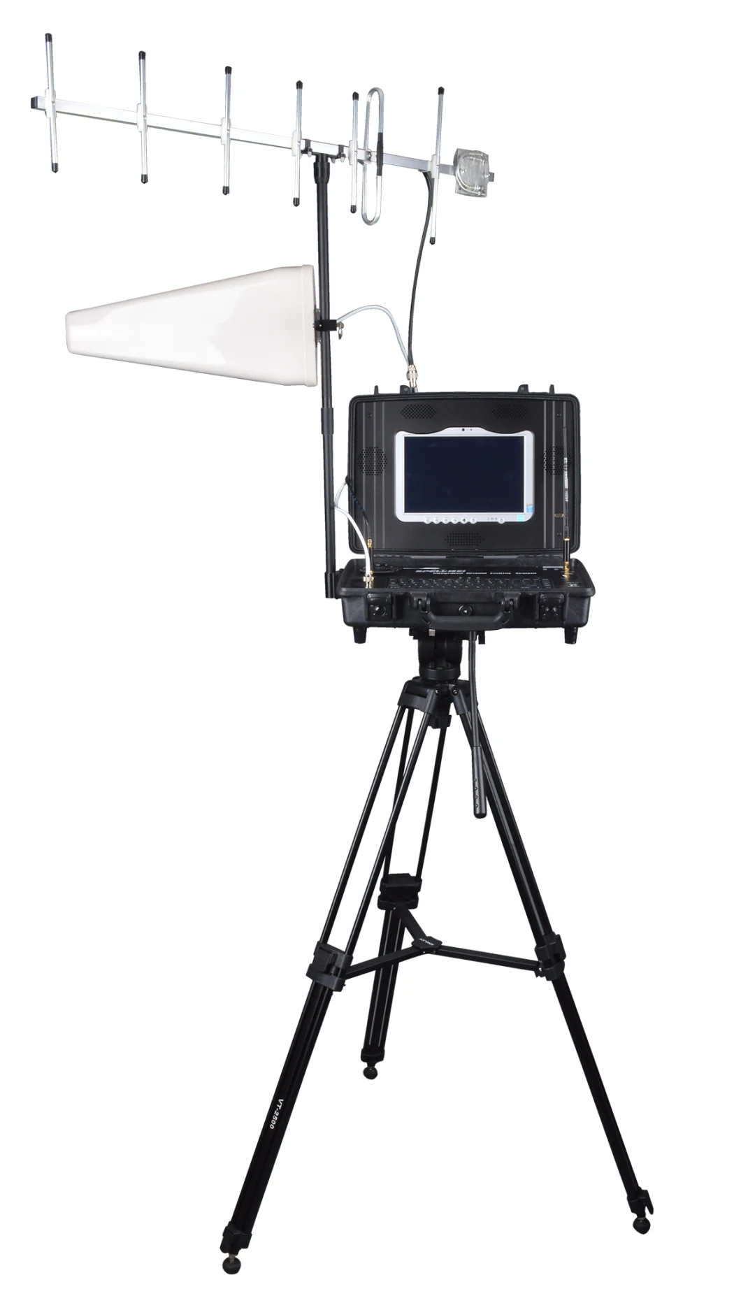
Features
- The ground station system uses the Intel i7 processor, which has powerful performance and smooth operation;
- High brightness display, low reflectivity, visible under strong light;
- Keyboard with touch pad and left and right mouse buttons for easy operation;
- Built-in 900MHz digital radio with automatic frequency hopping capability to effectively avoid external interference;
- Receive high-definition video of the transmitter on the aircraft and real-time display it;
- Support HDMI high-definition video output, can be used to connect large-screen display;
- Support local and front-end video recording and storage;
- Suitcase-style structure with tripod support, small in size and light in weight;
- Equipped with high-gain antenna to increase the distance of video transmission and digital radio.
Technical Specifications
| Ground station motherboard | CPU | Intel i7 processor |
| RAM | 4GB | |
| Digital radio | Frequency range | Frequency range 902-928MHz |
| Power output | 100mW-1W | |
| Receiving sensitivity | ≤-101dBm@115200bps | |
| Interface baud rate | 115200bps | |
| Air baud rate | 230400bps | |
| Video receiving | Frequency range | 170MHz-850MHz |
| Receiving sensitivity | ≤-92 dBm@8MHz ≤-95 dBm@2MHz | |
| RF bandwidth | 2/4/6/7/8MHz optional | |
| Output interface | USB | 2 |
| HDMI | 2 | |
| LAN port | 3 | |
| Display screen | 13.3 inch | Resolution 1920x1080, highlight with touch function |
| Power supply | Working voltage | DC19V |
| Working current | ≤4.4A | |
| Working time | >4.5 hours | |
| Battery model | BP-4S4P-3400 | |
| Battery nominal voltage | 14.4V | |
| Battery capacity | 13.4Ah | |
| Battery charging voltage | 16.8V±0.05V | |
| Battery charging mode | CC/CV (constant current / constant voltage) | |
| Battery charging current | 2.5A±100mA |
Brief introduction drone marine surveillance use
Through wireless data transmission link, the drone with different mission payloads can transmit the site information not only to the information processing and analysis system on the ground station that can forward the target information to the command center simultaneously, but also to the nearby cruise ships for quick response to the tasks. By dynamic surveillance and real time tracing on the maritime emergencies, ocean disaster and change of maritime environment, it offers real time field data for marine forecasters to make rapid alert, providing a scientific decision basis and solution for the maritime management department.
Regular patrol ships have disadvantages of low speed, narrow view, long patrol intervals and big limitation to natural conditions. Manned patrol aircrafts are influenced by the restriction of air traffic control with high use cost. However, the drone for maritime patrol features for low purchasing cost, low ground support requirements, strong maneuverability and no personnel security risks. More importantly, it offers a broad view, fast reaction and high work efficiency. The sea, the land and the air trinity comprehensive coverage can be realized when cooperated with Vessel Traffic System( VTS), patrol boats and law enforcement vessels, pushing the maritime static supervision gradually to the three dimensional supervision mode with dynamic static integration.
Marine environment surveillance
Spilled oil monitoring: cooperate with the sea patrol boats to make surveillance on the oil field work boats by using the drone to gather evidence of the spilled oil and chemical accidents. According to the task equipments like sensor and so on, the drone enables to monitor the sea pollution drift and diffusion situation, locate the sudden oil spill, and to estimate the oil spill area and drift path.
Emergency action: after oil spill and chemical accident, the drone can arrive at the accident scene at regular time and real time transmit the field scene to the command center.
Emission monitoring: through irregular night inspection to restrain night concealed emission.
Animal protection: irregular patrol on the protection sea for timely detection of stealing and poaching behavior.
Red tide monitoring and analysis: locate red tide area and ration red tide area.
Aftersales service
Offer local pilot training. Training course includes drone theory knowledge,field demo,practical flight training,drone maintenance and so on.